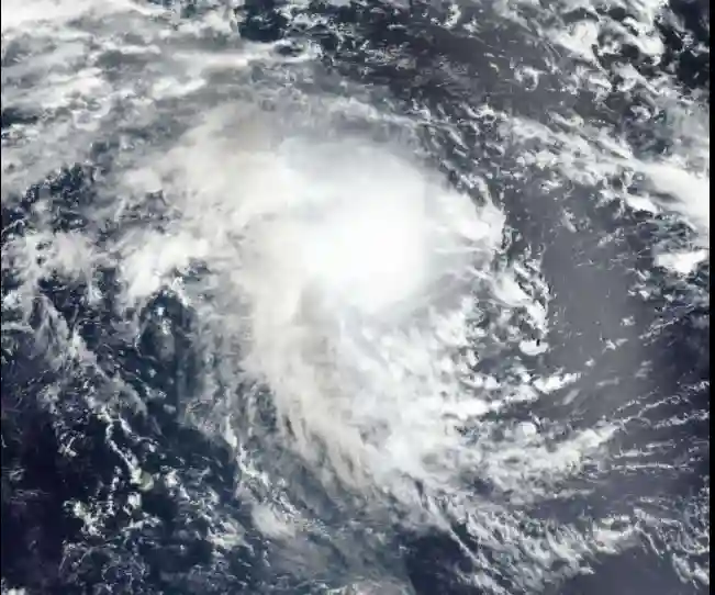
A severe Tropical Storm Emnati has formed and is tracking westwards in the Indian Ocean.
As of February 17, 2022, at 16:00 MUT, the storm’s center of circulation was approximately 1006 km (625 miles) northeast of Port Louis, Mauritius.
Forecast models indicate the system will strengthen as it tracks firstly westwards then west-southwestwards, becoming a tropical cyclone before passing to the north of Mauritius and Reunion between February 19 and 21.
Although Emnati’s center of circulation is currently forecast to pass around 400 km (249 miles) north of Mauritius and Reunion, the islands are still likely to be impacted by strong winds, rough seas, and heavy rainfall as the storm system passes.
Emnati is forecast to weaken slightly as it continues to track west-southwestwards towards Madagascar’s east coast and is currently expected to make landfall over central Madagascar as a tropical cyclone late February 22.
Some uncertainty remains in the track and intensity forecast, and changes could occur in the coming days.
On February 17, the Mauritius Meteorological Services issued a cyclone warning class 1 (the lowest level on a four tier-scale) for Rodrigues Island. Heavy rainfall, thunderstorms, strong winds, and rough seas are forecast to impact the island from late February 17 through at least February 18.
Authorities will likely issue new warnings or update existing advisories throughout the system’s progression in the coming days.
Sustained heavy rainfall could trigger flooding in low-lying areas and those with easily overwhelmed drainage systems. If weather conditions prove hazardous, localized evacuations, flash flooding, and landslides are possible.
The inclement weather could trigger localized business, transport, and utility disruptions and render some bridges or roadways impassable. Flight disruptions at airports on the affected islands and temporary closures of ports are also possible.
Stagnant pools of water during and after flooding increase insect- and waterborne diseases, such as dengue fever, cholera, and malaria. Exposure to raw sewage and other hazardous materials mixed with floodwaters poses a serious health threat.
Members of the public are advised to activate contingency plans in areas where officials forecast tropical storm conditions. They’re also advised to:
- Heed any evacuation orders that may be issued.
- Use extreme caution in low-lying coastal areas and near streams, creeks, and other waterways due to the potential for severe flooding and storm surge.
- Stockpile water, batteries, and other essentials in advance.
- Charge battery-powered devices when electricity is available; restrict the use of cellular phones to emergencies only.
- Power down mobile devices when not in use.
- Keep important documents and necessary medications in waterproof containers.
- Observe strict food and water precautions, as municipalities could issue boil water advisories following flooding events.
- Take precautions against insect- and waterborne diseases in the coming weeks.
- Plan accordingly for protracted commercial, transport, and logistics disruptions in areas in the path of the storm, especially if the vital infrastructure is damaged.
- Seek updated information on road conditions before driving or routing shipments through areas where flooding has occurred. Confirm flights before checking out of hotels or driving to the airport; clearing passenger backlogs may take several days in some locations.
More: Crisis24

