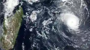
Tropical Cyclone Freddy has revived in the Mozambique Channel and is expected to intensify before making landfall in Mozambique again, but this time in northern parts of the country later this week.
Strong winds, storm surges and life-threatening flooding are possible.
On Tuesday afternoon, Freddy’s centre was just off the southwestern coast of Madagascar.
According to The Weather Channel, 6 to 17 inches of rain has been recorded in Ranohira and Tulear (Madagascar) Sunday into Monday due to outer rainbands wrapping around Freddy.
The tropical weather system is expected to track toward the northwest over the next several days, gaining strength until reaching the coast of northern Mozambique on Saturday, 11 March 2023.
Landfall is expected to be farther north than its first Mozambique landfall on 24 February.
Cyclone Freddy could set a world record for the longest-lasting, most intense tropical cyclone.
It began its journey as a tropical storm on 6 February south of Indonesia and rapidly intensified to Category 1 intensity the following day.
By 11 February, Cyclone Freddy rapidly intensified again to Category 3.
Eight days later, as a Category 5 storm, Freddy became the longest-lasting, most intense Southern Hemisphere tropical cyclone as measured by the ACE index – in records dating to 1980.
ACE is an abbreviation for accumulated cyclone energy, and is a metric used by scientists to measure the duration and intensity of tropical storms and hurricanes around the world.
The higher the ACE, the longer-lasting and more intense the tropical cyclone.
Fifteen days after it first became a tropical storm, Freddy became only the second southern Indian Ocean tropical cyclone in NOAA’s best track database to have reached at least Category 1 intensity and track from near Indonesia all the way to a Madagascar landfall.
Cyclone Eline/Leon in February 2000 was the only other storm to reach such an intensity as well as last and track that long.
Cyclone Freddy made landfall in southern Mozambique as a tropical storm on 24 February but quickly lost much of its intensity the following day.
By the time it entered southern Zimbabwe, Freddy’s remnant had downgraded to a low-pressure zone.
Instead of its remnant low dissipating over southern Africa, it made a U-turn and tracked eastward into the Mozambique Channel and became a tropical storm again last Friday.
More: Pindula News

